El domingo 6 de septiembre de 2009 fue un día aciago para mi vida marina. Comenzó fatal y terminó con la Roca del ahorcado !!!
Vamos con la bitácora personal.
Bitácora del 6 de septiembre de 2009
Hoy me toca de Patrón en prácticas.
Me falta práctica en organizar todo el trabajo de la tripulación.
Al final Pascal me propone subir la mayor aprovechando que tenemos viento de proa, que se dirige hacia la salida.
Christelle a la caña. El barco tiene demasiado impulso con el motor y la mayor algo cazada. Se pasa rozando el muerto por estribor, al igual que las boyas que están ligadas a la mayor de ellas.
El cabo pasa por la quilla y con el motor embragado. Parece que se ha enrollado en el motor. Se echa el ancla, como medida de seguridad, y a iniciativa de Julien.
El mismo Pascal se pone una combinación* (¿de Christelle?) para bucear y cortar el cabo. Es nuestro héroe.
Hay algo de caos posterior, en el rumbo que pasa el navegante Rodolfo. Se para el juego.
Pasamos por el mismo canal que ayer pero a la inversa, y algo más tensos.
Después se decide rodear por el norte las Scilly para llegar al New Grimsby Sound, con la Roca del ahorcado, el castillo de Cromwell y desembarcar en Tresco.
La marea está muy baja y hay que transportar el anexo hasta el caminito de Cromwell.
Casi todos se van a dar una vuelta por Tresco. Me quedo con Pascal en el pub, e intento encontrar un teléfono público ya que el micrófono de mi móvil ya no funciona. Al final un chico muy simpático, de la tienda de arte, que había trabajado en Gibraltar, me deja llamar con su propio teléfono.
Cenamos otra vez fish&chips y vuelta con el anexo, marea alta y viento contra corriente en el Sound. Bastante impresionante la corriente que domina al viento y las olas que se forman.
La vuelta parece que a Rodolfo le inspira la vida cuartelera, y Charles casi se muere de miedo al quedar el último en el anexo, sin remos, y un buen oleaje.
Además tenemos a un barco holandés, a menos de un metro, que nos ha golpeado con su proa en nuestra percha IOR. Buen ejercicio de Acta de daños, y día mediocre como Patrón en prácticas. Habrá que practicar.
- - - aclaración
* combinación == traje de buceo
- - - fin de la bitácora del 6 de septiembre - - -
Sin comentarios sobre la primera parte, nefasta, del día. La bitácora "oficial" no dice mucho más.
10H00. Arrêt suite à bout pris dans l'hélice. Pascal plonge pour defaire le bout, xxxx coupé. Puis Pascal est remonté sans probleme. Hélice claire dégagée et controlée. Mouillage.
[ Fotógrafo: naveganteglenan ]
También dice que el viento es del Sur F4 (S4B) y que llevamos la mayor con 2 rizos (GV2R) y solent. A las 13H20 tomamos un cofre en el canal New Grimsby Sound.
Corro un tupido velo. Sin embargo,
Google Maps me ayuda a
visualizar la última parte de la
navegación.
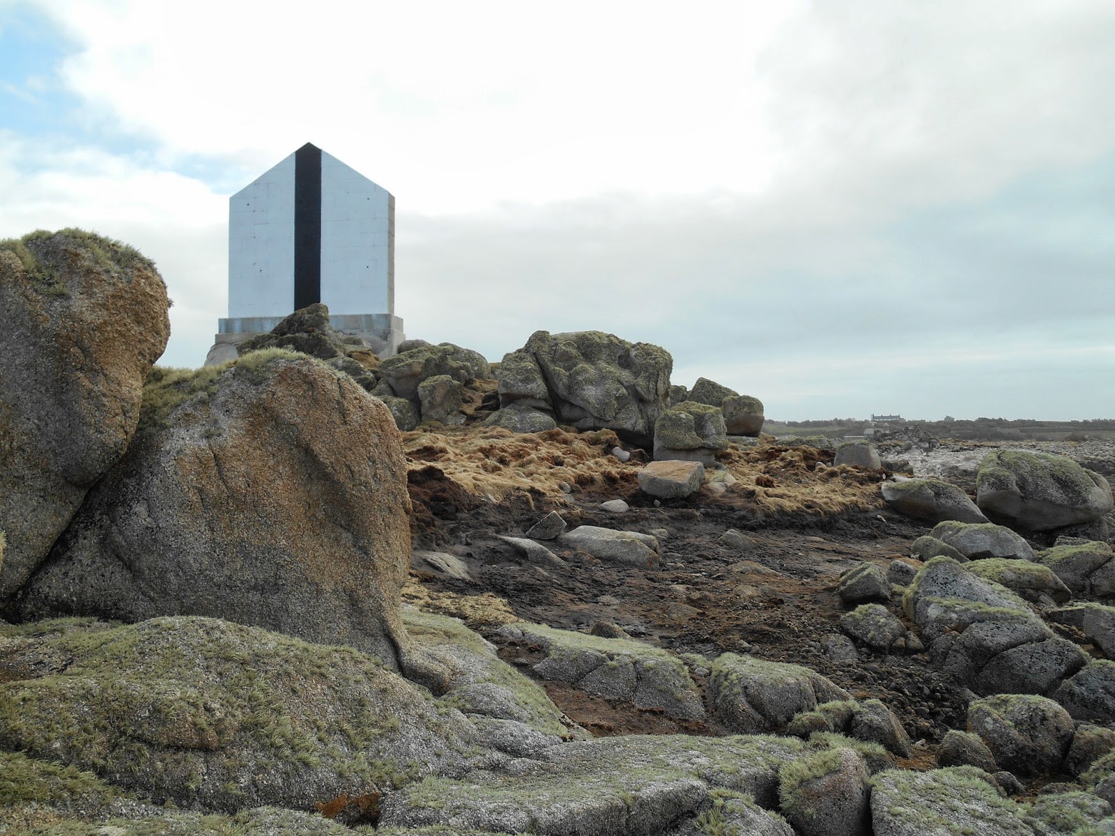
En esta última foto encuadro el Cromwell Castle en verde, la Hangman Island (Roca del ahorcado) en naranja y el pueblecito de New Grimsby en azul.
Desde la isla de Tresco, en lo alto del King Charles's Castle, se tiene una imagen simétrica (con los mismos colores :-)
Pinto con los mismos colores en Navionics.
Los de eOceanic siempre lo hace bien, pero aquí se lucen describiendo el New Grimsby Sound.
Para completar con los colores, una foto de Julien muestra muy bien donde fondeamos.
Como es de suponer desembarcamos en la isla de Tresco y nos dirigimos a un magnífico pub en New Grimsby: The New Inn.
Ahí estoy, con la foto de unos pescadores, y también están Julien y Pascal con pinturas de isleños a sus espaldas. Gracias Rodolfo.
Es cierto que en la galería de fotos de la web oficial del The New Inn aparecen muchas fotos y pinturas en las paredes.
Como las fotos de esa web son escasas, se me ha ocurrido buscar en Google Maps, pinchar en la etiqueta del pub, y después en "Ver fotos" se produce la magia. Con una buena dosis de paciencia se encuentra la siguiente foto.
¡
Todavía aparece la foto de la pareja de pescadores con niño que hace 15 años estaba a mis espaldas !
Lo he marcado con un recuadro azul... eso sí, la han cambiado de sitio, porque yo creo que estábamos en el rinconcito con las pinturas de isleños.
Volvimos, remando como pudimos, a nuestro Rose des Vents, y nos encontramos con desperfectos en la popa de nuestro barco. Julien hizo unas cuantas fotos de la excesiva proximidad de un colega. Por si acaso.
Christelle se encargo de redactar una extensa
Acta de daños, que añado, pero que no he llagado a saber si sirvió para algo. En cualquier caso,
chapeau Christelle, que eres
buena en todo :-)- - -